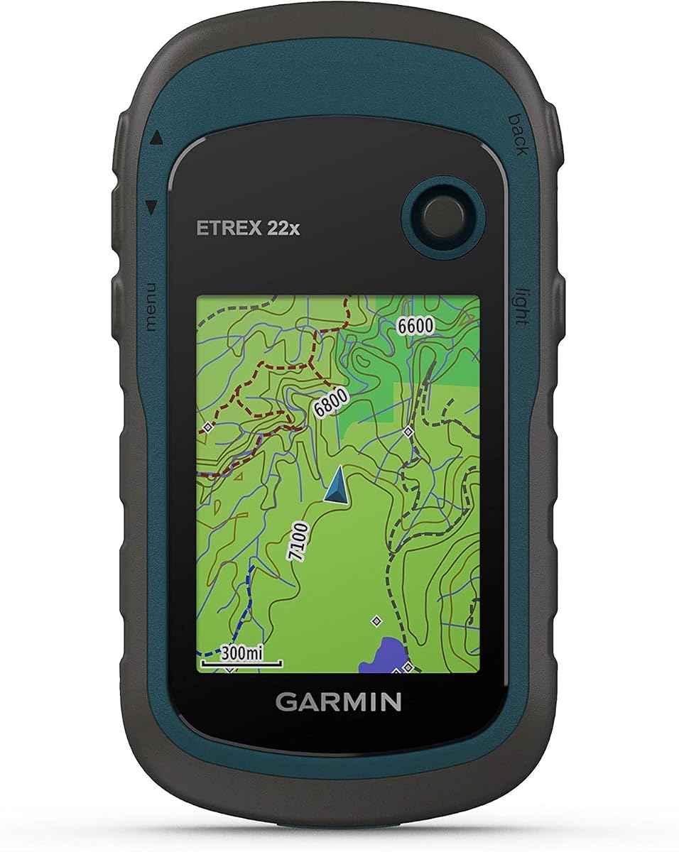
Garmin eTrex 22x
4.3Editor score
Sunlight-readable 2.2-inch display
Topo Active maps included
Long AA battery life
GPS navigation helps ATV riders stay oriented on unfamiliar trails, locate legal access points, record routes, and avoid unnecessary backtracking. A useful off-road navigator combines a sunlight-readable screen with detailed topographic mapping, accurate positioning, sturdy construction, and controls that remain workable with gloves. The right device also depends on whether you ride solo or in a group.
We compared all 10 products by examining their stated displays, mapping resources, positioning systems, navigation aids, environmental ratings, power options, group communication features, and storage. The list includes compact handheld units, powersport-specific navigators, and rugged motorcycle models that can be useful when their mounting and route capabilities suit an ATV setup.
Each review explains who the product is best positioned to serve, along with its strongest attributes and practical limitations. Ratings reflect the supplied customer feedback, while availability and pricing can change. Always confirm physical dimensions, power requirements, route coverage, and accessory compatibility before ordering equipment for your ATV.
4.3Editor score

4.2Editor score

4.7Editor score
As an Amazon Associate we earn from qualifying purchases.
The comparison highlights screen size, mapping orientation, group features, rugged construction, and power method across handheld, powersport, and motorcycle-style navigators. These differences help determine which device fits a solo trail rider, a group expedition, or an ATV setup with limited dashboard space.


The Garmin eTrex 22x is a compact handheld navigator with a 4.3 customer rating. It combines a sunlight-readable 2.2-inch color screen, preloaded Topo Active maps, support for both GPS and GLONASS, and an easy-to-replace AA battery design. That combination makes it a practical option for riders who want dependable navigation without carrying a large powered display.
We may earn a commission when you buy through this link, at no additional cost to you.
Its greatest strength is flexibility. Topo Active maps include routable roads and trails, while 8 GB of internal memory creates room for map downloads. A microSD card slot adds more storage, and dual-satellite support can be helpful in challenging terrain where a basic GPS-only receiver may have less coverage. The stated battery life reaches up to 25 hours in GPS mode with two AA batteries.
The compromises are size and interaction. A 2.2-inch display is not as easy to read at speed as the larger glove-friendly screens found on purpose-built powersport units, and the handheld format may require a secure mount for rough trails. It also does not provide the integrated group radio, touch route planner, or vehicle power wiring offered by several higher-ranked alternatives.
Choose the eTrex 22x if you are a budget-conscious rider who values long runtime, compact storage, and familiar handheld navigation. It is especially sensible for route scouting, trail marking, or occasional navigation where a small screen and removable batteries are acceptable. Riders wanting a large dashboard display and group communications should look toward the Tread models instead.
Two AA batteries and a stated runtime of up to 25 hours in GPS mode reduce the need to carry a separate charging setup. The compact body is also easier to stow than a dashboard navigator, making this unit useful for riders who alternate between navigation at the trailhead and quick course checks.
Preloaded Topo Active maps provide a useful starting point for both cycling and hiking routes. The internal memory and microSD slot allow map expansion, while GPS and GLONASS support improve positioning options in terrain where signal obstruction could be a concern.
We may earn a commission when you buy through this link, at no additional cost to you.
This renewed Garmin Tread Powersport carries a 4.5 rating and stands out for integrated communication rather than navigation alone. Its 5.5-inch ultrabright touchscreen is designed for off-road use, and the Group Ride Radio supports push-to-talk voice communication and location tracking for up to 20 riders using compatible Tread navigators.
We may earn a commission when you buy through this link, at no additional cost to you.
The device is purpose-built for powersport vehicles. It includes a powered mount, wiring harness, and tube mount, reducing the need to create a custom installation. Preloaded topographic and street maps cover North America, including public-land boundaries, Forest Service roads, and trails with Motor Vehicle Use Maps. BirdsEye Satellite Imagery is also available for download.
Smartphone pairing adds useful flexibility through the Tread app, including waypoint, track, and route syncing, GPX import and export, and live weather when a connection is available. Compatibility with optional inReach satellite communicators adds another layer of remote communication, although that equipment and its service are sold separately. The renewed status is the main uncertainty, as visible wear and included accessories may vary.
This Tread Powersport is a strong fit for organized ATV groups that value direct rider-to-rider communication. It is less appealing if you ride alone and need only local navigation, or if you prefer a recently manufactured unit. Confirm the condition, mounting hardware, power lead, and radio accessories before purchase.
The integrated fist microphone and push-to-talk radio remove one common gap in trail communication systems. Tracking up to 20 riders is valuable when a group splits across a switchback, enters a wooded section, or needs to regroup at a junction.
A powered tube mount and wiring harness provide a more ATV-appropriate foundation than a generic suction cup. The weather-resistant housing and glove-friendly display also support use in the rough conditions typical of off-road travel.
We may earn a commission when you buy through this link, at no additional cost to you.
The Garmin Tread 2 SxS Edition is the most expansive navigator in this group, with a 4.7 rating, an 8-inch ultrabright touchscreen, and an IP67 dust-and-water rating. It is designed for high-visibility off-road navigation, giving ATV and side-by-side riders more room to examine detailed trail maps without repeatedly zooming and panning.
We may earn a commission when you buy through this link, at no additional cost to you.
Its mapping is tailored to rugged travel. Turn-by-turn trail navigation uses OpenStreetMap, U.S. Forest Service Motor Vehicle Use Maps, and Adventure Roads and Trails content. High-definition elevation maps, private and public land information, campground details, and snow trails help riders understand the terrain beyond the immediate road. Subscription-free satellite imagery can be downloaded over Wi-Fi for an overhead view of the route.
The great rides feature lets users discover off-road routes, bookmark them, rate difficulty, and upload photos through the Tread app. A preloaded directory contains more than 46,000 public campground locations across the United States. Premium layers such as burn zones and night lights are available through Outdoor Maps+, which requires a subscription. Route suggestions should still be treated as supplemental information and deferred to posted signs and current conditions.
This edition is the premium choice for riders who want the largest, most detailed off-road view and can accommodate its footprint. It is particularly compelling for multi-day trips, public-land exploration, and side-by-side installations where visibility matters. Riders with a smaller ATV cockpit or limited mounting space may find the 6-inch Tread 2 more manageable.
The 8-inch display makes detailed trail intersections, elevation profiles, and land overlays easier to interpret. Glove-friendly operation is valuable when riders need to tap a destination or adjust a route while wearing protective gloves.
Downloaded satellite imagery provides a useful overview before entering an area with limited cellular service. This feature does not require a recurring map subscription, although Outdoor Maps+ content such as burn zones and night lights is separately subscription-based.
We may earn a commission when you buy through this link, at no additional cost to you.
The Garmin eTrex 32x builds on the eTrex 22x with a 4.2 rating, a 3-axis compass, and a barometric altimeter. It retains the familiar 2.2-inch sunlight-readable color display, GPS and GLONASS support, preloaded Topo Active mapping, 8 GB of internal memory, and a microSD expansion slot.
We may earn a commission when you buy through this link, at no additional cost to you.
The added electronic compass is particularly relevant for ATV riders who may travel beyond the reach of a clear horizon. A barometric altimeter supplies another reference for elevation, while dual satellite support broadens positioning options in challenging environments. Its two-AA battery arrangement continues to provide up to 25 hours in GPS mode and allows rapid battery replacement.
Compared with larger Tread and zūmo devices, the eTrex 32x offers fewer smart features, no integrated group radio, and a screen that is less suitable for entering complex routes while moving. Its strengths are simplicity, portability, and useful sensors. It can be mounted on an ATV or carried on route reconnaissance trips, provided the chosen mount holds it securely over rough terrain.
Choose the eTrex 32x when you want a conventional handheld navigator with more sensing capability than the 22x but do not need a large touch display or live group coordination. It is a sensible middle ground between minimal hardware and a full powersport dashboard system.
A three-axis compass provides directional information without requiring continuous travel for motion-based orientation. The barometric altimeter gives riders another way to monitor elevation, especially in changing terrain where route planning and campsite selection depend on altitude.
Eight gigabytes of internal memory and a microSD slot offer room for additional map data. Removable AA batteries are easy to carry as spares, and the compact form is easy to place in a map pocket, hydration pack, or secure handlebar-mounted case.
We may earn a commission when you buy through this link, at no additional cost to you.
The Garmin zūmo XT3 4.7-inch is a compact, rugged motorcycle navigator with a 4.2 rating. It combines a high-resolution sunlight-readable display, IP67 protection, detailed street and topographic maps, downloadable satellite imagery, and performance data that extends beyond basic turn-by-turn guidance.
We may earn a commission when you buy through this link, at no additional cost to you.
Its live lean-angle gauge shows how far the machine is leaned during a turn, while the Tread app can present ride summaries covering G-force, maximum speed, acceleration, and deceleration. With an active Garmin Performance Package, the device can also provide drag-race statistics, session performance, and lap times. Adventurous Routing prioritizes curvy, scenic, and hilly roads rather than simply selecting the fastest line.
Route creation is available through the on-device visual route planner or the Tread app. Group ride tracking requires a compatible phone, the app, and active cellular connections, while Outdoor Maps+ adds premium trail layers under a subscription. Although designed for motorcycles, these functions can appeal to ATV riders who prioritize performance metrics and paved-road exploration over direct radio communication.
The XT3 4.7 is best for riders who want a modern, compact navigator and appreciate performance analytics in a smaller footprint. It is less directly aligned with an ATV’s broad utility focus than the Tread Powersport models, so check the mount, power arrangement, and route style before committing.
Lean-angle, G-force, speed, and acceleration information can make a ride more engaging and reveal useful technique insights. The ability to review and share summaries through the Tread app adds value after the route is complete.
Adventurous Routing selects roads with more curves, hills, and scenic character, while Michelin scenic routes can be integrated or started directly from highlighted map routes. This is most relevant to mixed-surface rides that include substantial paved-road mileage.
We may earn a commission when you buy through this link, at no additional cost to you.
The renewed Garmin zūmo XT2 6-inch has a 4.0 rating and delivers a large, bright screen in an IPX7 housing designed to withstand handlebar vibration, harsh weather, and rough roads. Its core attraction is a visual route planner, paired with an option to favor efficient routes or more adventurous roads.
We may earn a commission when you buy through this link, at no additional cost to you.
The unit can display popular motorcycle paths and use satellite imagery to help riders discover new areas. The Tread app supports route planning, editing, and synchronization, while a group ride function shows other riders’ positions when devices are connected through the app. Ride summaries can report speed, elevation, acceleration, and deceleration after a trip.
Many features extend beyond navigation when paired with compatible equipment. It can handle navigation prompts, music, and hands-free calls through a compatible headset or helmet setup, and it supports optional inReach satellite communication, a Group Ride Radio, a BC 50 camera, and a Garmin PowerSwitch. Each additional device has separate requirements, including a subscription for compatible inReach service.
The XT2 6 is most compelling for riders who want a large display and a broad accessory ecosystem but are comfortable buying a renewed unit. Its motorcycle bias and smartphone-dependent features are less aligned with some ATV riders, and its lowest rating in the comparison suggests checking condition and included components carefully.
The visual route planner makes it easier to build a journey around preferred roads, while the Tread app allows routes to be planned, edited, and transferred. This combination is convenient for riders who alternate between detailed on-device control and phone-based preparation.
Speed, elevation, acceleration, and deceleration information gives riders a clearer record of each journey. Sharing features require the Tread app, and group position tracking depends on compatible devices and connectivity.
We may earn a commission when you buy through this link, at no additional cost to you.
The Garmin Tread 2 6-inch offers a balanced combination of screen space, off-road mapping, and powersport design. Its 4.2 rating reflects a broadly capable navigator with a 6-inch high-resolution touchscreen, an IP67 water rating, and a rugged form intended for extreme temperatures and rough off-road conditions.
We may earn a commission when you buy through this link, at no additional cost to you.
Trail navigation draws on OpenStreetMap, U.S. Forest Service Motor Vehicle Use Maps, and Adventure Roads and Trails content. High-definition elevation mapping, land information, campgrounds, snow trails, and City Navigator street maps create a versatile view for mixed on-road and off-road trips. Subscription-free satellite imagery can be downloaded over Wi-Fi, providing useful context before remote travel.
The app extends the device with GPX sharing, live weather radar, and group ride location tracking. Bluetooth-equipped phones and active cellular connections are required for the live group feature. Outdoor Maps+ adds advanced layers such as slope angle, slope aspect, and avalanche risk reports under a subscription. A rugged roll tube and handlebar mount provide installation flexibility.
This Tread 2 is the most versatile general recommendation for ATV riders who want a dedicated powersport navigator without moving to an 8-inch display. It offers enough screen for trail work, enough connectivity for planning, and enough sensors to help interpret terrain. Riders seeking direct radio communication should instead consider the Tread Powersport with Group Ride Radio.
Six inches provides enough room to read trail intersections and elevation information while remaining less imposing than an 8-inch housing. The glove-friendly touchscreen is designed for use in cold weather, dusty conditions, and while wearing full protective gear.
Offline satellite imagery helps riders visualize terrain and possible routes before connectivity disappears. Live weather, group tracking, and GPX exchange add planning and coordination features, although phone compatibility and cellular service are necessary for the connected functions.
We may earn a commission when you buy through this link, at no additional cost to you.
The factory-sealed Garmin Tread Powersport has a 4.4 rating and combines a 5.5-inch ultrabright, glove-friendly display with an integrated Group Ride Radio. It is designed specifically for powersport vehicles and supports push-to-talk voice communication plus group tracking for up to 20 riders using Tread navigators.
We may earn a commission when you buy through this link, at no additional cost to you.
Preloaded North American maps include topographic and street detail, public-land boundaries, Forest Service roads, and Motor Vehicle Use Maps. BirdsEye Satellite Imagery is downloadable, and the included powered mount, wiring harness, and tube mount create a complete installation package. The device also includes an altimeter, barometer, compass, gyroscope, and pitch-and-roll gauges for terrain awareness.
The Tread app can sync waypoints, tracks, and routes, import and export GPX files, and provide live weather when a connection is available. Optional inReach satellite communicators extend messaging and emergency functions beyond cellular coverage, but the accessory and active service are separate purchases. Compatibility with select Garmin dog systems, PowerSwitch, and BC 40 camera expands the system further.
Buy this version if you want a complete powersport navigation and communication setup without the uncertainty associated with a renewed unit. It is a strong match for clubs, guided groups, and riders traveling across remote areas where direct radio contact and physical trail maps matter. It offers less screen space and no advanced performance analytics than the zūmo XT3 models.
The included tube mount, powered mount, and wiring harness simplify installation on a compatible powersport vehicle. This is a meaningful advantage over a handheld unit that must be carried, repeatedly removed, or secured with a generic accessory.
The radio supports up to 20 riders with compatible Tread devices, making it more useful than simple location sharing when groups encounter confusing junctions. Satellite communication remains optional and should be used in accordance with local regulations.
We may earn a commission when you buy through this link, at no additional cost to you.
The Garmin zūmo XT3 6-inch bundle has a 4.2 rating and pairs the navigator with several useful supporting accessories. The package includes a wall charger, USB Type-A to Type-C cable, a power-bank battery, a two-port USB car adapter, a 32 GB memory card, and a display-cleaning kit.
We may earn a commission when you buy through this link, at no additional cost to you.
The navigator itself has a bright 6-inch display, an IPX7 water rating, and MIL-STD-810 durability. Detailed street and topographic maps provide broad route coverage, while downloadable satellite imagery can be stored without a subscription. Adventurous Routing favors curves, hills, and scenic roads, and the Tread app supports custom route planning plus GPX, KML, and KMZ imports.
Ride data includes lean angle, G-force, maximum speed, acceleration, and deceleration, with drag-race timing and lap-time review available through an active Garmin Performance Package. Group tracking depends on compatible devices and connectivity. Optional off-grid communication accessories can expand the system, although they are not part of the stated bundle contents.
This bundle is a good choice for riders who want a larger performance-focused navigator and several supporting accessories at the same time. For ATV use, it may require more adaptation than a Tread unit because its feature emphasis is motorcycles, paved-road adventure, and track performance. Confirm that its mount, power arrangement, and route priorities suit your vehicle.
The 6-inch display provides room for live lean-angle information, a detailed map, and ride metrics. Its vibration-resistant design and IPX7 rating support use on demanding roads and in changing weather.
The bundled memory card, charging equipment, car adapter, and power bank cover several common preparation needs. Buyers should still verify that a mount suitable for the ATV is included, because a device bundle does not necessarily contain every vehicle-specific fitting.
We may earn a commission when you buy through this link, at no additional cost to you.
The Garmin zūmo XT3 4.7-inch bundle has a 5.0 customer rating, the highest listed score among the ten products. It combines a compact high-resolution display with an IPX7 water rating, MIL-STD-810 durability, and a package of charging, storage, power, and cleaning accessories.
We may earn a commission when you buy through this link, at no additional cost to you.
Street and topographic maps cover on-road and off-road navigation, and satellite imagery can be downloaded over Wi-Fi without a subscription. Adventurous Routing allows riders to favor curves, hills, and scenic roads with adjustable difficulty. The visual route planner and Tread app support custom routes, while GPX, KML, and KMZ files can be imported for more flexible planning.
Performance tools record lean angle, G-force, maximum speed, acceleration, and deceleration, with track data shared through the app. An active Garmin Performance Package adds drag-race timing and lap-time review. Group tracking, weather, traffic, notifications, and related smartphone functions also require appropriate app and connectivity support.
Choose this bundle for riders who want the XT3 platform in its most compact form and value the included accessories. The 4.7-inch screen is easier to fit on a crowded handlebar than the larger XT3, but it offers less space for detailed map inspection. ATV riders should confirm mounting, power, and route suitability because the device is marketed primarily for motorcycles.
The 4.7-inch display balances visibility with a smaller physical footprint. It remains suitable for sunlight and glove operation, while lean-angle and acceleration data bring performance awareness to both touring and track-oriented riding.
The included 32 GB card, power bank, car adapter, cables, wall charger, and cleaning kit reduce the need to purchase basic support items separately. Custom routing and multiple file formats make it easier to bring in planned trails, while satellite downloads remain available without a recurring subscription.
We may earn a commission when you buy through this link, at no additional cost to you.
The most useful ATV GPS is one that combines accurate positioning, detailed trail mapping, a readable glove-operated display, secure power, and construction suited to vibration, dust, and weather. Route style, screen size, group needs, and offline capabilities should guide the final choice.
Look for a device that does more than display roads. Topographic content, public-land boundaries, Forest Service roads, Motor Vehicle Use Maps, elevation detail, snow trails, and campground information can help a rider understand where a route leads and whether it crosses private or restricted land. The Garmin Tread 2 models and Tread Powersport units offer the broadest off-road map focus, while the eTrex devices provide preloaded Topo Active maps suitable for more traditional handheld navigation. Riders should also check whether map coverage extends to the areas they plan to visit rather than assuming every region receives the same trail detail.
Screen size affects how quickly a rider can understand an upcoming junction. The 2.2-inch eTrex displays are portable and readable but require more attention and physical button input. Six-inch models offer a stronger balance for trail decisions, while the 8-inch Tread 2 SxS Edition provides the largest viewing area. Glove-friendly touch operation, high brightness, and sunlight readability matter more on moving ATVs than maximum pixel count. Riders with crowded handlebars may prefer the 4.7-inch zūmo XT3, whereas riders with a broad roll cage may benefit from the Tread 2's larger options.
A GPS that shifts, vibrates loose, or blocks controls is not useful on rough trails. The Tread Powersport products include a powered tube mount and wiring harness, and the Tread 2 6-inch offers tube and handlebar mounting options. Motorcycle-oriented zūmo units may require a suitable ATV mount that is not part of every bundle. Check handlebar diameter, control clearance, power-lead routing, display visibility from a seated position, and the strength of the attachment. Handheld eTrex units are easiest to carry, but they need a secure enclosure if mounted on a moving vehicle.
GPS and GLONASS support can improve acquisition options in challenging terrain, while a compass and altimeter add useful information between trail markers. The eTrex 32x adds a three-axis compass and barometric altimeter, while the Tread and zūmo products include broader sensor suites with altimeter, barometer, compass, and pitch-and-roll gauges. These sensors do not replace responsible trail riding, but they can make it easier to interpret direction, elevation, and terrain attitude. Buyers should avoid assuming that all units use identical satellite systems or provide the same electronic compass.
Group riding changes the value of communication features. The Tread Powersport units include a push-to-talk Group Ride Radio and can track as many as 20 riders using compatible Tread navigators. Other Garmin models can display group locations through the Tread app, but they generally depend on compatible smartphones, Bluetooth, and active cellular connections. Optional inReach satellite communicators can provide two-way messaging and emergency functions in places without cellular coverage, though they require separate hardware and an active subscription. Compare direct radio functionality with app-based tracking before choosing a group system.
Battery strategy can determine whether a navigator is practical for a long day. The eTrex 22x and 32x use two AA batteries and offer up to 25 hours in GPS mode, making them easy to power and service. Vehicle-mounted Tread and zūmo devices generally use powered installations that avoid uncertainty during a long ride, but require compatible wiring and secure connections. If an ATV has limited electrical access, assess whether a removable battery, power bank, or alternative charging arrangement is preferable. Low-brightness settings, planned route preparation, and a backup handheld can also reduce the risk of navigation loss.
Downloaded satellite imagery is valuable when cellular service disappears, and several devices support subscription-free downloads through Wi-Fi. Some premium layers, including Outdoor Maps+ content such as burn zones, night lights, slope information, and avalanche risk reports, require a subscription. App-based functions also vary: route syncing, live weather, group positions, notifications, and performance summaries may require a compatible smartphone and active data connection. Decide which features must work completely offline and which can depend on the phone before making a purchase.
ATV navigation equipment is exposed to vibration, dust, moisture, temperature changes, and repeated impacts. Garmin's listed ratings vary across the range: the eTrex units are described as rugged handhelds, the Tread Powersport devices carry IPX7 weather resistance, and the Tread 2 models have IP67 ratings. The zūmo XT3 is built for vibration, harsh weather, and rough conditions, with MIL-STD-810 durability noted for the bundled versions. A rating does not replace sensible mounting, but it provides useful evidence that the housing is intended for demanding use. Keep connectors protected and follow the manufacturer’s care instructions.
Before the first ride, install the unit according to the manufacturer’s instructions, confirm that the display is readable from a normal seated position, and check that the mount does not interfere with steering, throttle, brake, or accessory controls. Connect the appropriate power source, secure loose wiring, and protect connectors from moisture and moving components. For a handheld unit, use a closed, vibration-resistant mount rather than leaving it loose in a storage compartment.
Plan the route while connected to Wi-Fi or using the relevant app, then download the necessary maps and imagery for areas with no service. Save key waypoints and carry a backup map or charged phone. Before moving, confirm that the unit is displaying the intended position, that the route preview does not require an unnecessary private-road crossing, and that offline functions have been activated and tested.
During the ride, set the screen brightness appropriately, keep alerts audible, and avoid complicated interaction while moving at unsafe speeds. Pull over before changing a large route or reviewing detailed data. After returning, clean the screen and housing with a soft damp cloth, remove the unit if it will be stored for a long period, inspect the mount and wiring, and recharge or replace batteries according to the power method.
A motorcycle GPS can work on an ATV when its mapping, power, and mounting system are appropriate for the vehicle. Motorcycle-oriented zūmo models emphasize paved-road adventure and performance features, while Garmin Tread powersport models are designed specifically around off-road vehicle use. Confirm screen size, vibration resistance, power requirements, and mount availability before installation.
A handheld GPS is often easier to carry and can offer long battery runtime, making it useful for route reconnaissance or occasional navigation. A dashboard GPS is generally better for continuous guidance because its larger screen and vehicle power are easier to consult while riding. The ideal choice depends on mounting security, available cockpit space, and how frequently the navigator will be used.
Core navigation can work offline when the required maps are stored on the device. Several Garmin models support downloadable satellite imagery without a subscription, while live weather, group positions, phone notifications, and some premium map layers require connectivity. Download maps and imagery before leaving cellular coverage and verify that any optional service is active before the trip.
GPS and GLONASS are two satellite navigation systems that a receiver can use to determine position. Supporting both can provide additional satellites and potentially improve tracking in challenging environments compared with relying on one system alone. It does not guarantee perfect accuracy, especially under dense canopy, among tall rock formations, or in other heavily obstructed terrain.
Yes, but the communication method varies. Tread Powersport units include a push-to-talk Group Ride Radio and support tracking for up to 20 compatible riders. Other Garmin navigators can display rider locations through the Tread app when compatible phones, Bluetooth, and active cellular connections are available. For remote areas, optional satellite communicators can add messaging and emergency functions.
Several Garmin models in this comparison support direct, subscription-free satellite imagery downloads over Wi-Fi. Optional premium content through Outdoor Maps+, including certain burn-zone, night-light, slope, and avalanche layers, does require a subscription. Check each product’s feature list if those specialized layers are important to your trip.
Use a mount designed for the surface and movement of the vehicle, allowing the display to be read without blocking safety-critical controls. Route power cables away from pedals, levers, suspension movement, and hot components, and use weather-resistant connections where appropriate. Tighten fasteners according to the mount instructions and recheck them after the first rough ride.
Many of these devices support both on-road and off-road travel. Tread and zūmo models include street and topographic content, while the eTrex units feature Topo Active maps with routable roads and trails. The best choice depends on how much paved mileage you cover and whether you need performance metrics, direct radio communication, or a more compact handheld design.
The Garmin eTrex 22x is the value-focused choice for riders who prioritize portability, replaceable AA batteries, and a long stated runtime. The Garmin Tread 2 6-inch is the most versatile all-round recommendation, combining a glove-friendly display, trail-focused mapping, offline imagery, and connected planning. For riders who want the largest off-road view and the most detailed terrain presentation, the Tread 2 SxS Edition stands out as the premium option.
Group riders have a different priority: the Tread Powersport with Group Ride Radio provides direct voice communication and tracking for compatible riders, especially valuable on remote routes. Riders who mostly travel on paved roads or visit tracks may prefer the zūmo XT3 for its larger performance-oriented display, lean-angle data, and adventurous road routing. In every case, verify vehicle fit, map coverage, power requirements, and app dependencies before purchase.
Product availability, bundle contents, and pricing can change over time, so check the current listing before making a final decision. Read customer feedback alongside the stated specifications, confirm that needed mounts and cables are included, and keep an offline backup for remote rides. The right navigator is the one that provides the needed information clearly, survives the installation, and works when service does not.
